Open menu

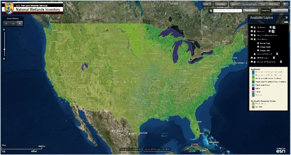
The Wetland Mapping Consortium (WMC), founded in 2008, is an interdisciplinary group of wetland scientists and managers interested in mapping and monitoring wetlands with remotely sensed images and/or using the resultant products to best manage wetland resources. The WMC Steering Committee organizes webinars on topics of interest to the group.

If you haven’t used Teams before or you just need a refresher, please view our guide prior to the webinar here

For more information and/or to join our email list for notices about upcoming events, please contact Laura Burchill at laura@nawm.org or (207) 892-3399.  

Past Wetland Mapping Consortium Webinars Here

List of Wetland Mapping Consortium Webinar Recordings Here
  

New Tools for Efficient and Effective Desktop Wetland Delineation in the Chesapeake Bay Watershed

Wednesday, December 17, 2025 - 3:00 p.m.-4:30 p.m. EST 

PRESENTERS

  • Mike Evans, Chesapeake Conservancy
  • Jes Skillman, Ducks Unlimited, Great Lakes/Atlantic Region
  • Evelyn Magner, Ducks Unlimited

BIOS

Michael Evans is Deputy Director with the Conservation Innovation Center and leads research that improves conservation policy, decision-making, and implementation. He is responsible for developing the Chesapeake Conservancy's use of data science and technology, including the application of deep learning and remote sensing data to better understand land-use dynamics. He earned a Ph.D. in natural resource management from the University of Connecticut where his research helped state agencies understand how the space use and movements of black bears change across gradients of human landscape modification. 

Jes SkillmanJes Skillman has over 12 years' experience in Conservation GIS at Ducks Unlimited. She currently manages and coordinates the Geospatial Department of Duck’s Unlimited’s Great Lakes / Atlantic office. In this role, Ms. Skillman works closely with partners, the DU Conservation Team, and the DU GIS team to develop baseline data, priority area mapping tools, and web applications that align with conservation goals. Ms. Skillman has a BA in Ecology from the University of Toronto and a Masters in Conservation Biology from the University of Michigan. 


Evelyn MagnerEvelyn Magner has experience as a GIS professional in conservation non-profits, including 4 years of National Wetland Inventory mapping. Prior to joining Ducks Unlimited, Evelyn worked with various nonprofits, supporting their conservation efforts with the creation of maps and web applications for communication and planning purposes. She holds a Bachelor of Arts in environmental studies and geography and a Master of Science in applied ecology.


Register Here